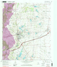
1995 Map of Rockwall
USGS Topo · Published 2002About this map
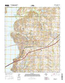
Lake Ray Hubbard dominates the western landscape of this mid-1990s survey, its shoreline defining the growth patterns of Rockwall and Heath. The expansion of these suburban communities is evident in the dense residential networks spreading east from the water, contrasting with the more rural character of Fate and McLendon - Chisholm. Genealogists will find several burial sites preserved amidst the development, including Mt Zion Cem and Clark Cem. The topography reveals the intricate drainage of Squabble Creek and Buffalo Creek into the reservoir, while an Old Railroad Grade north of the city serves as a reminder of earlier transportation corridors. Further east, the Zollner Ranch and Rockwall Municipal Airport highlight the mix of agricultural heritage and modern utility that characterized the county at the end of the 20th century.
Find a feature on this map
47 named features on this map. Tap any name to fly to it.
Don’t see what you’re looking for? This feature index may not catch every label — zoom into the map to look around manually.
Map Details
Editions of this 1995 Rockwall Map
This is the sole edition of this map. No revisions or reprints were ever made.
Historical Maps of Dallas Through Time
8 maps found