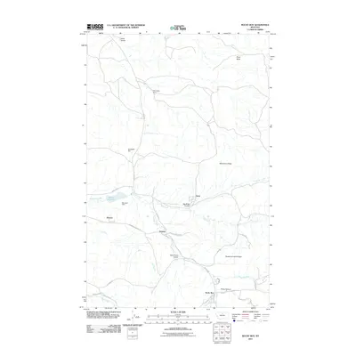
2011 Map of Rocky Boy
USGS Topo · Published 2011About this map
Rocky Boy and the surrounding Hill County landscape are defined by a complex network of coulees and high ridges at the start of the 21st century. The map details small settlements like Sangrey and Azure, connected by locally significant routes such as Agency Rd and Sangrey School Rd. The hydrography is dominated by seasonal and perennial drainage systems, notably Wolf Creek and Boxelder Creek, which feed into infrastructure like Bonneau Dam and the Bonneau Reservoir. Significant topographical features like Pasquowmustus Ridge and Wild Horse Ridge provide a clear view of the area's elevation changes, while family and local landmarks such as Champagne Ranch, Gardipee Hill, and Parker Canyon offer specific points of interest for genealogists and local historians tracing the development of this northern Montana community.
Find a feature on this map
34 named features on this map. Tap any name to fly to it.
Don’t see what you’re looking for? This feature index may not catch every label — zoom into the map to look around manually.
Map Details
Editions of this 2011 Rocky Boy Map
This is the sole edition of this map. No revisions or reprints were ever made.
Other maps of this area

1953 · Havre
USGS Topo · 1:250,000

1957 · Havre
USGS Topo · 1:250,000

1958 · Havre
USGS Topo · 1:250,000

1959 · Warrick
USGS Topo · 1:62,500

1959 · Laredo
USGS Topo · 1:62,500

1959 · Centennial Mountain
USGS Topo · 1:62,500

1959 · Shambo
USGS Topo · 1:62,500
1970 · Laredo
USGS Topo · 1:24,000
1984 · Bearpaw Lake
USGS Topo · 1:24,000
1984 · Laredo NE
USGS Topo · 1:24,000