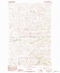
1984 Map of Rocky Boy
USGS Topo · Published 1984About this map
The Rocky Boys Indian Reservation dominates this mid-1980s landscape, illustrating a complex terrain of ridges and drainages at the border of Hill and Chouteau counties. The settlement of Rocky Boy serves as a focal point in the southern portion of the map, situated near the headwaters of Boxelder Creek. The geography is defined by prominent elevations such as Wild Horse Ridge, Pasquowmustus Ridge, and Gardipee Hill, which dictate the flow of numerous seasonal coulees including Reifer Coulee and Gravel Coulee. Water management is evident at Boneau Reservoir, while the natural drainage network is represented by Wolf Creek, Duck Creek, and the Dry Fork. This provisional survey preserves the specific local nomenclature of the Bear Paw Mountains region, capturing the spatial relationship between tribal lands and the surrounding high plains and canyons like Parker Canyon.
Find a feature on this map
18 named features on this map. Tap any name to fly to it.
Don’t see what you’re looking for? This feature index may not catch every label — zoom into the map to look around manually.
Map Details
Editions of this 1984 Rocky Boy Map
This is the sole edition of this map. No revisions or reprints were ever made.
Other maps of this area

1953 · Havre
USGS Topo · 1:250,000

1957 · Havre
USGS Topo · 1:250,000

1958 · Havre
USGS Topo · 1:250,000

1959 · Warrick
USGS Topo · 1:62,500

1959 · Laredo
USGS Topo · 1:62,500

1959 · Centennial Mountain
USGS Topo · 1:62,500

1959 · Shambo
USGS Topo · 1:62,500
1970 · Laredo
USGS Topo · 1:24,000
1984 · Bearpaw Lake
USGS Topo · 1:24,000
1984 · Laredo NE
USGS Topo · 1:24,000