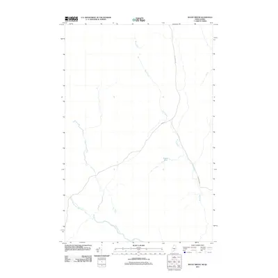
2011 Map of Rocky Brook
USGS Topo · Published 2011About this map
Rocky Brook carves a winding path through this northern borderland, defining a landscape shaped by water and timber transport near the boundary between Maine and Quebec. This 2011 survey documents a sparsely settled region dominated by the drainage systems of the Little Black River and its West Branch, which flow through the southern portion of the quadrangle. The network of forest roads, including Rocky Brook Rd and Irving Rd, provides the primary infrastructure for access across the terrain. Located in the vicinity of Rideout Pond, the map illustrates a transition point where local waterways served as the backbone for regional movement and industry. The presence of international boundary markers, coordinated by the International Boundary Commission, emphasizes the importance of this remote corridor where the hydrology of the North Woods remains the most prominent feature of the land.
Find a feature on this map
6 named features on this map. Tap any name to fly to it.
Don’t see what you’re looking for? This feature index may not catch every label — zoom into the map to look around manually.
Map Details
Editions of this 2011 Rocky Brook Map
This is the sole edition of this map. No revisions or reprints were ever made.
Other maps of this area

1930 · Allagash
USGS Topo · 1:48,000

1933 · Allagash
USGS Topo · 1:62,500

1955 · Rocky Mountain
USGS Topo · 1:62,500

1955 · Rocky Brook
USGS Topo · 1:62,500

1955 · Beau Lake
USGS Topo · 1:62,500

1962 · Edmundston
USGS Topo · 1:250,000
1987 · Johnson Brook Mountain
USGS Topo · 1:24,000

1987 · Hafey Pond
USGS Topo · 1:24,000
1987 · Saint-Eleuthere
USGS Topo · 1:24,000
1987 · Morrison Brook
USGS Topo · 1:24,000