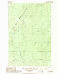
1987 Map of Rocky Brook
USGS Topo · Published 1987About this map
The Canada United States border cuts through this northern Maine landscape, where the Little Black River winds through a heavily forested timberland in Aroostook County. In the late 1980s, the area remained dominated by commercial logging interests, marked by networks of Private roads and multiple Gravel Pits used for maintenance. The international boundary is defined by the Québec Maine line, separating the Maine townships from the Municipalité de Saint-Athanase and MRC de Témiscouata. Small bodies of water like Lac Packington and Rideout Pond dot the drainage basins of Beaver Branch and Rocky Brook. This terrain reflects a working forest environment, where geography is organized more by township and range lines like T 19 R 12 W E L S than by established towns, offering a detailed look at the hydrology and access routes used by the timber industry at the time.
Find a feature on this map
21 named features on this map. Tap any name to fly to it.
Don’t see what you’re looking for? This feature index may not catch every label — zoom into the map to look around manually.
Map Details
Editions of this 1987 Rocky Brook Map
This is the sole edition of this map. No revisions or reprints were ever made.
Other maps of this area

1930 · Allagash
USGS Topo · 1:48,000

1933 · Allagash
USGS Topo · 1:62,500

1955 · Rocky Mountain
USGS Topo · 1:62,500

1955 · Rocky Brook
USGS Topo · 1:62,500

1955 · Beau Lake
USGS Topo · 1:62,500

1962 · Edmundston
USGS Topo · 1:250,000
1987 · Johnson Brook Mountain
USGS Topo · 1:24,000

1987 · Hafey Pond
USGS Topo · 1:24,000
1987 · Saint-Eleuthere
USGS Topo · 1:24,000
1987 · Morrison Brook
USGS Topo · 1:24,000