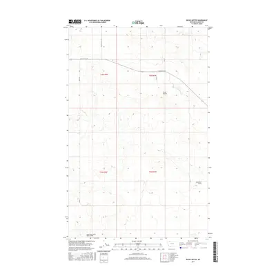
2017 Map of Rocky Buttes
USGS Topo · Published 2017About this map
Rocky Buttes dominate the central landscape of this Glacier County quadrangle, a terrain defined by the high plains of northern Montana. The map documents a sparse network of gravel and unimproved roads, including Chalk Butte Rd and Landslide Butte Rd, which serve the expansive agricultural sections of t36n r8w and t36n r7w. The hydrology of the area is centered on the drainage patterns of Little Rock Coulee and the South Fork Little Rock Coulee, which carve subtle paths through the prairie. This 2017 survey provides a precise look at the modern rural layout, showing how early 20th-century land divisions still dictate the path of local routes like Brown Rd across the high northern plains.
Find a feature on this map
10 named features on this map. Tap any name to fly to it.
Don’t see what you’re looking for? This feature index may not catch every label — zoom into the map to look around manually.
Map Details
Editions of this 2017 Rocky Buttes Map
This is the sole edition of this map. No revisions or reprints were ever made.
Other maps of this area

1907 · Blackfoot Res.
USGS Topo · 1:48,000

1909 · Cut Bank
USGS Topo · 1:125,000

1911 · Blackfoot
USGS Topo · 1:125,000

1912 · Cut Bank
USGS Topo · 1:125,000

1960 · Cut Bank
USGS Topo · 1:250,000

1963 · Cut Bank
USGS Topo · 1:250,000

1964 · Cut Bank
USGS Topo · 1:250,000
1966 · Gunsight
USGS Topo · 1:24,000

1968 · Buffalo Lake
USGS Topo · 1:24,000
1968 · Dead Indian Spring
USGS Topo · 1:24,000