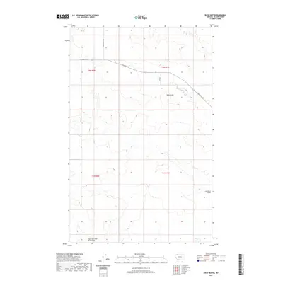
2020 Map of Rocky Buttes
USGS Topo · Published 2020About this map
Rocky Buttes stands as the central landmark in this portion of Glacier County, characterizing a landscape defined by its high-plains relief and seasonal drainage patterns. The 2020 topography illustrates the transition from high ground into the winding cuts of the South Fork Little Rock Coulee and Little Rock Coulee. These watercourses reveal the underlying geological erosion common to the northern Montana plains. Human presence is etched into the terrain primarily through a sparse network of section-line and topographic roads, including Chalk Butte Rd and Landslide Butte Rd. These routes follow the natural contours of the land, connecting disparate ranching or agricultural sites across the wide townships of T36N and T35N. The map provides a precise view of the land before further modern development, preserving the spatial relationship between the high buttes and the coulees that drain them.
Find a feature on this map
10 named features on this map. Tap any name to fly to it.
Don’t see what you’re looking for? This feature index may not catch every label — zoom into the map to look around manually.
Map Details
Editions of this 2020 Rocky Buttes Map
This is the sole edition of this map. No revisions or reprints were ever made.
Other maps of this area

1907 · Blackfoot Res.
USGS Topo · 1:48,000

1909 · Cut Bank
USGS Topo · 1:125,000

1911 · Blackfoot
USGS Topo · 1:125,000

1912 · Cut Bank
USGS Topo · 1:125,000

1960 · Cut Bank
USGS Topo · 1:250,000

1963 · Cut Bank
USGS Topo · 1:250,000

1964 · Cut Bank
USGS Topo · 1:250,000
1966 · Gunsight
USGS Topo · 1:24,000

1968 · Buffalo Lake
USGS Topo · 1:24,000
1968 · Dead Indian Spring
USGS Topo · 1:24,000