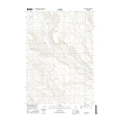
2017 Map of Rocky Creek
USGS Topo · Published 2017About this map
Medicine Lodge Cr carves a significant drainage through this section of Clark County, defining the local geography alongside Rocky Creek. The terrain is marked by a network of drainage basins and named depressions including Spring Hollow and Lake Hollow, which suggest the seasonal movement of water through this high-elevation landscape. Transportation in this area is limited to a handful of established routes that follow the natural contours of the land, such as Medicine Lodge Rd and Webber Creek Rd. This 2017 survey reflects a largely undeveloped landscape where the intersection of water sources like Deep Cr and Middle Cr dictate the layout of the sparse road system. The map serves as a detailed record of the hydrography and topography of the region, tracing the paths of various forks and creeks that feed into larger systems.
Find a feature on this map
20 named features on this map. Tap any name to fly to it.
Don’t see what you’re looking for? This feature index may not catch every label — zoom into the map to look around manually.
Map Details
Editions of this 2017 Rocky Creek Map
This is the sole edition of this map. No revisions or reprints were ever made.
Other maps of this area

1955 · Dubois
USGS Topo · 1:250,000

1957 · Paul Reservoir
USGS Topo · 1:62,500

1957 · Edie Ranch
USGS Topo · 1:62,500

1958 · Dubois
USGS Topo · 1:250,000

1964 · Small
USGS Topo · 1:24,000

1969 · Shamrock Gulch
USGS Topo · 1:24,000

1969 · Lidy Hot Springs
USGS Topo · 1:24,000

1983 · Dubois
USGS Topo · 1:100,000
1987 · Indian Creek
USGS Topo · 1:24,000
1987 · Fritz Peak
USGS Topo · 1:24,000