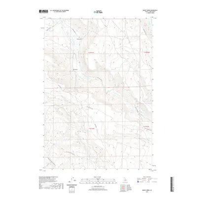
2020 Map of Rocky Creek
USGS Topo · Published 2020About this map
Medicine Lodge Cr carves a significant drainage through this high-elevation Idaho landscape, accompanied by a network of seasonal and perennial waterways that define the local topography. This 2020 survey illustrates the remote character of Clark County, where geographic features like Spring Hollow and Lake Hollow serve as critical landmarks in an area dominated by open range and steep relief. A system of unpaved roads and trails, including Medicine Lodge Rd and Deep Creek-Antelope Lakes Rd, provides the primary access to this backcountry. The drainage patterns of Deep Cr and the S Fork Deep Cr reveal the complex hydraulic network feeding into larger basins. This map is particularly useful for understanding modern land use and access routes through the remote corridors of the Intermountain West.
Find a feature on this map
20 named features on this map. Tap any name to fly to it.
Don’t see what you’re looking for? This feature index may not catch every label — zoom into the map to look around manually.
Map Details
Editions of this 2020 Rocky Creek Map
This is the sole edition of this map. No revisions or reprints were ever made.
Other maps of this area

1955 · Dubois
USGS Topo · 1:250,000

1957 · Paul Reservoir
USGS Topo · 1:62,500

1957 · Edie Ranch
USGS Topo · 1:62,500

1958 · Dubois
USGS Topo · 1:250,000

1964 · Small
USGS Topo · 1:24,000

1969 · Shamrock Gulch
USGS Topo · 1:24,000

1969 · Lidy Hot Springs
USGS Topo · 1:24,000

1983 · Dubois
USGS Topo · 1:100,000
1987 · Indian Creek
USGS Topo · 1:24,000
1987 · Fritz Peak
USGS Topo · 1:24,000