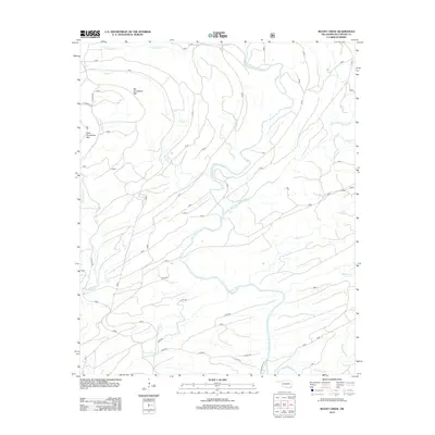
2013 Map of Rocky Creek
USGS Topo · Published 2013About this map
The Glover River watershed dominates this part of McCurtain County, where the West Fork and East Fork converge amidst high ridges. The terrain is defined by prominent elevations such as Big Horseshoe Mtn and Little Horseshoe Mtn, which guide the drainage of numerous small tributaries including Winship Br and Rocky Cr. While the landscape is primarily defined by its hydrology, a network of forest and ranch roads provides access to the interior. Traces of human activity and land use are visible through named routes like Clealik Rd and the Jones Ranch Trl. The map details a complex system of creeks, from Terrapin Cr in the west to Beeman Cr and North Carter Cr in the east, illustrating the intricate natural drainage patterns characteristic of this part of Oklahoma.
Find a feature on this map
19 named features on this map. Tap any name to fly to it.
Don’t see what you’re looking for? This feature index may not catch every label — zoom into the map to look around manually.
Map Details
Editions of this 2013 Rocky Creek Map
This is the sole edition of this map. No revisions or reprints were ever made.
Other maps of this area

1901 · Alikchi
USGS Topo · 1:125,000

1902 · Lukfata
USGS Topo · 1:125,000

1950 · Mcalester
USGS Topo · 1:250,000

1959 · Golden
USGS Topo · 1:62,500

1960 · Bethel
USGS Topo · 1:62,500

1962 · McAlester
USGS Topo · 1:250,000

1962 · Alikchi
USGS Topo · 1:24,000

1962 · Signal Mountain
USGS Topo · 1:24,000

1965 · McAlester
USGS Topo · 1:250,000
1972 · Clebit
USGS Topo · 1:24,000