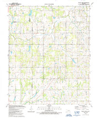
1991 Map of Rocky Ford
USGS Topo · Published 1991About this map
Rocky Ford and the small settlement of Acme anchor this landscape along the border of Grady, Caddo, and Comanche counties. The terrain is defined by the winding course of the Little Washita River and its various tributaries, including McCarty Creek and Charlie Creek. Evidence of the region’s petroleum industry is prominent, particularly within the Rush Creek Oil and Gas Field on the eastern edge of the survey, where numerous gas and oil wells dot the countryside.
Find a feature on this map
18 named features on this map. Tap any name to fly to it.
Don’t see what you’re looking for? This feature index may not catch every label — zoom into the map to look around manually.
Map Details
Editions of this 1991 Rocky Ford Map
This is the sole edition of this map. No revisions or reprints were ever made.
Other maps of this area

1902 · Rush Springs
USGS Topo · 1:125,000

1949 · Cement
USGS Topo · 1:62,500

1949 · Nellie
USGS Topo · 1:62,500

1949 · Rush Springs
USGS Topo · 1:62,500

1950 · Rush Springs
USGS Topo · 1:62,500

1950 · Marlow
USGS Topo · 1:62,500

1951 · Marlow
USGS Topo · 1:62,500

1955 · Lawton
USGS Topo · 1:250,000

1956 · Sterling
USGS Topo · 1:24,000

1956 · Laverty
USGS Topo · 1:24,000