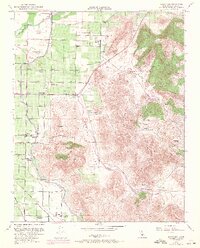
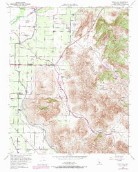
1951 Map of Rocky Hill
USGS Topo · Published 1971About this map
Agricultural lands and citrus groves meet the rising foothills of the Sierra Nevada in this Tulare County survey. The Kaweah River and Consolidated Peoples Ditch dominate the northern irrigation landscape, feeding a network of canals and levees that support settlements like Lindcove and Merryman. The terrain is defined by the prominent Badger Hill and Rocky Hill, which overlook the Yokohl Valley. Local history is visible in the distribution of family holdings such as Hamilton Ranch and Powell Ranch, alongside the Hamilton Cemetery. Of particular cultural significance is the recorded Dumtah (Indian Camp Ground Site) near Dry Creek. Transportation infrastructure at mid-century included the Visalia Electric and Southern Pacific railroads, alongside the Atchison Topeka and Santa Fe line, illustrating the region's importance as a rail-dependent transit hub for central valley produce.
Find a feature on this map
40 named features on this map. Tap any name to fly to it.
Don’t see what you’re looking for? This feature index may not catch every label — zoom into the map to look around manually.
Map Details
Editions of this 1951 Rocky Hill Map
5 editions found
Other maps of this area

1904 · Kaweah
USGS Topo · 1:125,000

1909 · Kaweah
USGS Topo · 1:125,000

1925 · Rocky Hill
USGS Topo · 1:31,680

1926 · Ivanhoe
USGS Topo · 1:31,680

1926 · Exeter
USGS Topo · 1:31,680

1927 · Cairns Corner
USGS Topo · 1:31,680

1927 · Rocky Hill
USGS Topo · 1:31,680

1928 · Lemon Cove
USGS Topo · 1:31,680

1928 · Lindsay
USGS Topo · 1:31,680

1937 · Kaweah
USGS Topo · 1:125,000