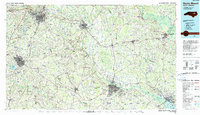
1985 Map of Rocky Mount
USGS Topo · Published 1990About this map
The Tar River and Roanoke River systems dominate this eastern North Carolina landscape, anchoring a network of historic river towns including Tarboro, Williamston, and Greenville. By the mid-1980s, the region shows a dense intersection of transportation history, where the tracks of the Seaboard Coast Line RR and Norfolk Southern RR cross major transit corridors like US Highway 301. The map reveals the intricate drainage patterns of the Inner Coastal Plain, featuring extensive wetlands such as Toisnot Swamp and Nahunta Swamp that influenced early settlement and agriculture. Smaller communities like Pinetops, Bethel, and Stantonsburg appear alongside distinctive terrain features like Penny Hill and Frying Pan Bend, providing a clear record of the spatial relationship between these rural centers and the growing urban hubs of Rocky Mount and Wilson.
Find a feature on this map
159 named features on this map. Tap any name to fly to it.
Don’t see what you’re looking for? This feature index may not catch every label — zoom into the map to look around manually.
Map Details
Editions of this 1985 Rocky Mount Map
2 editions found
Other maps of this area

1901 · Parmele
USGS Topo · 1:62,500

1901 · Williamston
USGS Topo · 1:62,500

1902 · Kenly
USGS Topo · 1:62,500

1902 · Williamston
USGS Topo · 1:62,500

1902 · Parmele
USGS Topo · 1:62,500

1902 · Ayden
USGS Topo · 1:62,500

1902 · Rocky Mount
USGS Topo · 1:62,500

1902 · Spring Hope
USGS Topo · 1:62,500

1902 · Vanceboro
USGS Topo · 1:62,500

1902 · Tarboro
USGS Topo · 1:62,500