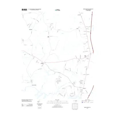
2013 Map of Rocky Point
USGS Topo · Published 2013About this map
Turkey Creek and its many meandering tributaries, including Morgans Creek and Long Creek, dominate the low-lying drainage patterns of this coastal plain landscape. The settlement of Rocky Point serves as a central hub, where residential streets like Railroad St and Casha Rd meet the primary north-south corridors. Small community nodes and historical crossroads are scattered throughout the region, from Bells Crossroads and Clarks Landing in the south to Twin Oak and Ashton in the north. The map reveals a transition between rural land use and developing residential pockets, with family-named landmarks such as Newells Holw and Kellys Creek reflecting the area's local heritage. Evidence of historical industry and resource management appears in labels like Saw Mill Rd and Mill Branch Dr, indicating the long-standing importance of timber and water power to the local economy.
Find a feature on this map
119 named features on this map. Tap any name to fly to it.
Don’t see what you’re looking for? This feature index may not catch every label — zoom into the map to look around manually.
Map Details
Editions of this 2013 Rocky Point Map
This is the sole edition of this map. No revisions or reprints were ever made.
Other maps of this area

1942 · Burgaw
USGS Topo · 1:62,500

1947 · Rocky Point
USGS Topo · 1:62,500

1953 · Florence
USGS Topo · 1:250,000

1953 · Beaufort
USGS Topo · 1:250,000

1954 · Florence
USGS Topo · 1:250,000

1954 · Beaufort
USGS Topo · 1:250,000

1954 · Acme
USGS Topo · 1:62,500

1955 · Atkinson
USGS Topo · 1:62,500

1970 · Scotts Hill
USGS Topo · 1:24,000
1970 · Castle Hayne
USGS Topo · 1:24,000