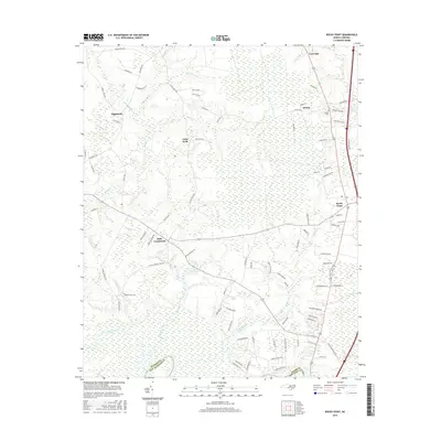
2016 Map of Rocky Point
USGS Topo · Published 2016About this map
Rocky Point and its surrounding coastal plain communities are defined by a complex network of blackwater streams and wetlands in this Pender County landscape. The area is anchored by several small settlements including Bells Crossroads, Ashton, and Highsmith, which serve as focal points for the rural road system. The presence of the Burgaw Savannah and extensive drainages like Turkey Creek, Long Creek, and Morgans Cr illustrate the low-lying, hydrologically active nature of this region. Local history and genealogy are anchored by established burial grounds such as Rileys Creek Cem and Hocutt Cem. The map traces the boundary between Pender and New Hanover counties, showing the transition of the landscape as it moves toward the Atlantic coast, with numerous family-named landmarks like Little Kelly and Twin Oak providing evidence of long-term community identity.
Find a feature on this map
92 named features on this map. Tap any name to fly to it.
Don’t see what you’re looking for? This feature index may not catch every label — zoom into the map to look around manually.
Map Details
Editions of this 2016 Rocky Point Map
This is the sole edition of this map. No revisions or reprints were ever made.
Other maps of this area

1942 · Burgaw
USGS Topo · 1:62,500

1947 · Rocky Point
USGS Topo · 1:62,500

1953 · Florence
USGS Topo · 1:250,000

1953 · Beaufort
USGS Topo · 1:250,000

1954 · Florence
USGS Topo · 1:250,000

1954 · Beaufort
USGS Topo · 1:250,000

1954 · Acme
USGS Topo · 1:62,500

1955 · Atkinson
USGS Topo · 1:62,500

1970 · Scotts Hill
USGS Topo · 1:24,000
1970 · Castle Hayne
USGS Topo · 1:24,000