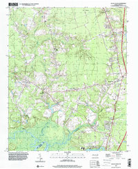
1997 Map of Rocky Point
USGS Topo · Published 2000About this map
Rocky Point and its surrounding coastal plain communities appear here as they were transitioning toward the end of the millennium. The landscape is defined by the winding course of the Northeast Cape Fear River and its numerous tributaries, including Long Creek and Turkey Creek. This area of Pender County shows a clear pattern of small, localized settlements such as Little Kelly, St Helena, and Ashton, often centered around crossroads and rural religious centers like Antioch Ch and Friendship Ch. The mapping reveals the educational and social infrastructure of the time, evidenced by the Pender Academy near the main settlement of Rocky Point. While modern development like mobile home parks began to appear along the corridors, the vast wetlands and creek networks like Morgans Creek still dictated the layout of the region's roads and property lines.
Find a feature on this map
30 named features on this map. Tap any name to fly to it.
Don’t see what you’re looking for? This feature index may not catch every label — zoom into the map to look around manually.
Map Details
Editions of this 1997 Rocky Point Map
This is the sole edition of this map. No revisions or reprints were ever made.
Other maps of this area

1942 · Burgaw
USGS Topo · 1:62,500

1947 · Rocky Point
USGS Topo · 1:62,500

1953 · Florence
USGS Topo · 1:250,000

1953 · Beaufort
USGS Topo · 1:250,000

1954 · Florence
USGS Topo · 1:250,000

1954 · Beaufort
USGS Topo · 1:250,000

1954 · Acme
USGS Topo · 1:62,500

1955 · Atkinson
USGS Topo · 1:62,500

1970 · Scotts Hill
USGS Topo · 1:24,000
1970 · Castle Hayne
USGS Topo · 1:24,000