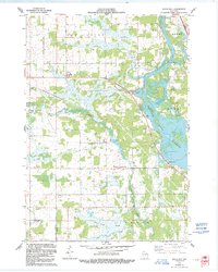
1970 Map of Rocky Run
USGS Topo · Published 1991About this map
Mill Creek Community sits at the heart of this central Wisconsin landscape, where the confluence of several major waterways defines the local geography. The massive Wisconsin River Flowage dominates the eastern boundary, fed by the winding course of Mill Creek and Rocky Run. In the north, the waters of Eau Pleine intersect with the primary river system near First Lake and Second Lake, illustrating a complex riparian environment managed for both transit and resource use.
Find a feature on this map
24 named features on this map. Tap any name to fly to it.
Don’t see what you’re looking for? This feature index may not catch every label — zoom into the map to look around manually.
Map Details
Editions of this 1970 Rocky Run Map
2 editions found
Other maps of this area

1955 · Green Bay
USGS Topo · 1:250,000

1956 · Milladore
USGS Topo · 1:48,000

1956 · Stevens Point
USGS Topo · 1:48,000

1957 · Wisconsin Rapids
USGS Topo · 1:48,000

1957 · Whiting
USGS Topo · 1:48,000

1967 · Wisconsin Rapids
USGS Topo · 1:62,500

1970 · Junction City
USGS Topo · 1:24,000

1970 · Stevens Point
USGS Topo · 1:24,000
1970 · Rocky Run
USGS Topo · 1:24,000
1970 · Meehan
USGS Topo · 1:24,000