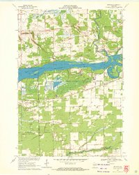
1970 Map of Meehan
USGS Topo · Published 1972About this map
The Wisconsin River Flowage bisects this Central Wisconsin landscape, creating a distinct water-bound boundary between the townships of Linwood and Plover. At the center of this hydro-electric and recreational corridor lies Pleasure Island, while the surrounding terrain is a mosaic of agricultural and industrial land use. To the south, specialized agriculture is evident at the Cranberry Bog, a hallmark of the region's economy.
Find a feature on this map
33 named features on this map. Tap any name to fly to it.
Don’t see what you’re looking for? This feature index may not catch every label — zoom into the map to look around manually.
Map Details
Editions of this 1970 Meehan Map
2 editions found
Other maps of this area

1955 · Green Bay
USGS Topo · 1:250,000

1956 · Milladore
USGS Topo · 1:48,000

1956 · Stevens Point
USGS Topo · 1:48,000

1957 · Wisconsin Rapids
USGS Topo · 1:48,000

1957 · Whiting
USGS Topo · 1:48,000

1967 · Wisconsin Rapids
USGS Topo · 1:62,500

1970 · Kellner
USGS Topo · 1:24,000

1970 · Junction City
USGS Topo · 1:24,000

1970 · Stevens Point
USGS Topo · 1:24,000
1970 · Bancroft
USGS Topo · 1:24,000