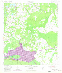
1949 Map of Rodman
USGS Topo · Published 1972About this map
Ocklawaha Lake dominates the southern landscape of this Florida region, reflecting significant 20th-century hydrological changes. The 1970 photorevised data, shown in purple, highlights the expansion of water across the terrain following the construction of the Cross Florida Barge Canal. This infrastructure fundamentally altered the course of the Oklawaha River and the surrounding cypress swamps like Cow Heaven Bay and The Slash. In the north, the Seaboard Coast Line railroad connects small settlements such as Hollister and Hunter, while the southern portion reaches into the dense Ocala National Forest. Local industry is evidenced by a Sawmill and the landing at Cedar Landing, while the presence of Rainbow Ranch and Rodman provides specific points of interest for genealogists tracing family locations near the Putnam and Marion county line.
Find a feature on this map
27 named features on this map. Tap any name to fly to it.
Don’t see what you’re looking for? This feature index may not catch every label — zoom into the map to look around manually.
Map Details
Editions of this 1949 Rodman Map
3 editions found
Other maps of this area

1912 · Palatka
USGS Topo · 1:48,000

1915 · Palatka
USGS Topo · 1:62,500

1915 · Interlachen
USGS Topo · 1:48,000

1916 · Interlachen
USGS Topo · 1:62,500

1944 · Interlachen
USGS Topo · 1:62,500

1949 · Keuka
USGS Topo · 1:24,000

1949 · Baywood
USGS Topo · 1:24,000

1949 · Rodman
USGS Topo · 1:24,000
1949 · Putnam Hall
USGS Topo · 1:24,000

1949 · Interlachen
USGS Topo · 1:62,500