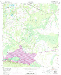
1949 Map of Rodman
USGS Topo · Published 1972About this map
Interlachen and the surrounding pine lands of Putnam County are captured here in a period of significant hydrological and industrial transition. The map centers on the Ocklawaha Lake and the Oklawaha River, documenting the infrastructure of the Cross Florida Barge Canal as it cuts through the landscape. To the south, the Ocala National Forest begins at the Putnam Co Marion Co boundary, where Blue Springs and Cedar Landing sit along the riverbanks. The Seaboard Coast Line railroad runs through the northern reaches, connecting the small settlements of Hollister and Hunter. Notable land features include the curiously named Cow Heaven Bay and The Slash, while localized industry is marked by a Sawmill and the Ferry crossing near the county line.
Find a feature on this map
28 named features on this map. Tap any name to fly to it.
Don’t see what you’re looking for? This feature index may not catch every label — zoom into the map to look around manually.
Map Details
Editions of this 1949 Rodman Map
3 editions found
Other maps of this area

1912 · Palatka
USGS Topo · 1:48,000

1915 · Palatka
USGS Topo · 1:62,500

1915 · Interlachen
USGS Topo · 1:48,000

1916 · Interlachen
USGS Topo · 1:62,500

1944 · Interlachen
USGS Topo · 1:62,500

1949 · Keuka
USGS Topo · 1:24,000

1949 · Baywood
USGS Topo · 1:24,000

1949 · Rodman
USGS Topo · 1:24,000
1949 · Putnam Hall
USGS Topo · 1:24,000

1949 · Interlachen
USGS Topo · 1:62,500