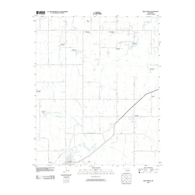
2009 Map of Roff North
USGS Topo · Published 2009About this map
The town of Roff sits at the headwaters of the Blue River in this 2009 survey, showcasing a landscape defined by water management and local transit. The area is marked by a significant concentration of flood control structures, including the Oknoname 11904 Dam and a series of sites along Canadian Sandy Creek. These dams and reservoirs emphasize the agricultural and hydrological importance of the drainage basins feeding the river. To the east, the community of Fitzhugh is situated along the roadway network, while landmarks such as Chimney Hill and Dry Hollow provide topographic variation. The map serves as a detailed record of local genealogy and infrastructure, capturing both the West Hill Cemetery and East Hill Cemetery on the outskirts of Roff. Connectivity is provided by the Chickasaw Tpke, which cuts diagonally through the southern half of the quadrangle, linking these small Oklahoma settlements to the broader region.
Find a feature on this map
40 named features on this map. Tap any name to fly to it.
Don’t see what you’re looking for? This feature index may not catch every label — zoom into the map to look around manually.
Map Details
Editions of this 2009 Roff North Map
This is the sole edition of this map. No revisions or reprints were ever made.
Other maps of this area

1901 · Stonewall
USGS Topo · 1:125,000

1957 · Ardmore
USGS Topo · 1:250,000

1958 · Ada
USGS Topo · 1:24,000

1963 · Ardmore
USGS Topo · 1:250,000

1967 · Roff South
USGS Topo · 1:24,000

1967 · Ahloso
USGS Topo · 1:24,000
1967 · Vanoss
USGS Topo · 1:24,000
1967 · Stratford
USGS Topo · 1:24,000

1967 · Roff North
USGS Topo · 1:24,000
1967 · Fittstown
USGS Topo · 1:24,000