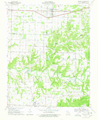
1970 Map of Rogersville
USGS Topo · Published 1978About this map
Rogersville serves as the primary hub on this Ozarks landscape, situated along the St Louis - San Francisco rail line. The terrain transitions from the relatively flat agricultural lands of Washington and Benton townships into a complex network of hollows and ridges to the south. Finley Creek meanders across the lower half of the quadrangle, feeding into Lindenlure Lake near the western boundary. A notable cluster of family and community landmarks, such as Holland Cem, Spillman Cem, and Tallman Cem, provides a detailed record of local settlement history.
Find a feature on this map
60 named features on this map. Tap any name to fly to it.
Don’t see what you’re looking for? This feature index may not catch every label — zoom into the map to look around manually.
Map Details
Editions of this 1970 Rogersville Map
3 editions found
Other maps of this area

1884 · Springfield
USGS Topo · 1:125,000

1886 · Springfield
USGS Topo · 1:125,000

1907 · Forsyth
USGS Topo · 1:125,000

1937 · Galloway
USGS Topo · 1:24,000

1937 · Bradleyville
USGS Topo · 1:48,000

1937 · Ozark
USGS Topo · 1:48,000

1939 · Fordland
USGS Topo · 1:62,500

1942 · Fordland
USGS Topo · 1:62,500

1943 · Ozark
USGS Topo · 1:62,500

1943 · Bradleyville
USGS Topo · 1:62,500