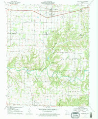
1970 Map of Rogersville
USGS Topo · Published 1978About this map
Finley Creek carves a deep, winding path through the Ozark plateau in this 1970 snapshot, defining the rural character where Greene, Christian, and Webster counties meet. The town of Rogersville sits at the northern edge along the St Louis-San Francisco railroad, serving as a transit point for the surrounding agricultural landscape. Further south, the map reveals a rugged terrain of timbered hollows and ridges, such as Peck Ridge and Bishop Hollow, which historically dictated the placement of small settlements and family farms.
Find a feature on this map
60 named features on this map. Tap any name to fly to it.
Don’t see what you’re looking for? This feature index may not catch every label — zoom into the map to look around manually.
Map Details
Editions of this 1970 Rogersville Map
3 editions found
Other maps of this area

1884 · Springfield
USGS Topo · 1:125,000

1886 · Springfield
USGS Topo · 1:125,000

1907 · Forsyth
USGS Topo · 1:125,000

1937 · Galloway
USGS Topo · 1:24,000

1937 · Bradleyville
USGS Topo · 1:48,000

1937 · Ozark
USGS Topo · 1:48,000

1939 · Fordland
USGS Topo · 1:62,500

1942 · Fordland
USGS Topo · 1:62,500

1943 · Ozark
USGS Topo · 1:62,500

1943 · Bradleyville
USGS Topo · 1:62,500