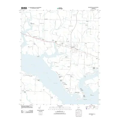
2011 Map of Rogersville
USGS Topo · Published 2011About this map
Rogersville serves as the focal point of this landscape, situated along the northern banks of the expansive Wheeler Lake. The geography is defined by the massive reach of the Tennessee River and its confluence with the Elk River, creating a complex shoreline dotted with residential developments like Ramblewood Shores and Ferry Shores. This survey documents a high density of family and community burial grounds, such as the Old Romine Cemetery and Little Zion Cemetery, which provide vital touchstones for genealogical research in this part of Lauderdale County.
Find a feature on this map
133 named features on this map. Tap any name to fly to it.
Don’t see what you’re looking for? This feature index may not catch every label — zoom into the map to look around manually.
Map Details
Editions of this 2011 Rogersville Map
This is the sole edition of this map. No revisions or reprints were ever made.
Other maps of this area

1914 · Rogersville
USGS Topo · 1:48,000

1916 · Rogersville
USGS Topo · 1:62,500

1936 · Union Hill
USGS Topo · 1:24,000

1936 · Thorntontown
USGS Topo · 1:24,000

1936 · Courtland
USGS Topo · 1:24,000

1936 · Lexington
USGS Topo · 1:24,000

1936 · Hillsboro
USGS Topo · 1:24,000

1936 · Wheeler Dam
USGS Topo · 1:24,000

1936 · Town Creek
USGS Topo · 1:24,000
1936 · Center Hill
USGS Topo · 1:24,000