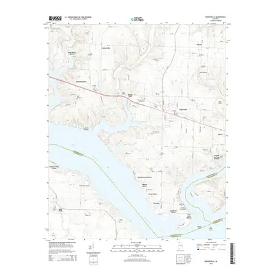
2014 Map of Rogersville
USGS Topo · Published 2014About this map
Rogersville sits at the heart of this landscape north of the Tennessee River, where the waters of Wheeler Lake define the southern boundary and separate Lauderdale County from Lawrence and Limestone Counties. The map reveals a high density of rural burial grounds, including the Old Romine Cem, Thornton Cem, and Whitehead Cem, which offer significant value for genealogical research in this portion of northern Alabama. The topography is marked by distinctive features such as Saltpeter Cave Bluff and Elk River Shoals, reflecting the unique riverfront geology. Residential growth and recreational interests are evident in the numerous shorefront communities like Pine Haven Shores and Ramblewood Shores, while the presence of Wheeler Dam Village points to the long-standing impact of hydroelectric infrastructure on the local economy and settlement patterns.
Find a feature on this map
134 named features on this map. Tap any name to fly to it.
Don’t see what you’re looking for? This feature index may not catch every label — zoom into the map to look around manually.
Map Details
Editions of this 2014 Rogersville Map
This is the sole edition of this map. No revisions or reprints were ever made.
Other maps of this area

1914 · Rogersville
USGS Topo · 1:48,000

1916 · Rogersville
USGS Topo · 1:62,500

1936 · Union Hill
USGS Topo · 1:24,000

1936 · Thorntontown
USGS Topo · 1:24,000

1936 · Courtland
USGS Topo · 1:24,000

1936 · Lexington
USGS Topo · 1:24,000

1936 · Hillsboro
USGS Topo · 1:24,000

1936 · Wheeler Dam
USGS Topo · 1:24,000

1936 · Town Creek
USGS Topo · 1:24,000
1936 · Center Hill
USGS Topo · 1:24,000