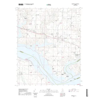
2018 Map of Rogersville
USGS Topo · Published 2018About this map
Rogersville and the surrounding riverfront communities sit at a major transition point where the Elk River meets the expansive waters of Wheeler Lake. The landscape is defined by the legacy of early settlements and family lineages, evidenced by the high density of memorial sites such as the Old Romine Cem, Liberty Cem, and the Oliver-Bedingfield Memorial Cem. These cemeteries, often tucked near creek branches like Nugent Br and Mill Br, offer significant value for genealogical research in Lauderdale County.
Find a feature on this map
178 named features on this map. Tap any name to fly to it.
Don’t see what you’re looking for? This feature index may not catch every label — zoom into the map to look around manually.
Map Details
Editions of this 2018 Rogersville Map
This is the sole edition of this map. No revisions or reprints were ever made.
Other maps of this area

1914 · Rogersville
USGS Topo · 1:48,000

1916 · Rogersville
USGS Topo · 1:62,500

1936 · Union Hill
USGS Topo · 1:24,000

1936 · Thorntontown
USGS Topo · 1:24,000

1936 · Courtland
USGS Topo · 1:24,000

1936 · Lexington
USGS Topo · 1:24,000

1936 · Hillsboro
USGS Topo · 1:24,000

1936 · Wheeler Dam
USGS Topo · 1:24,000

1936 · Town Creek
USGS Topo · 1:24,000
1936 · Center Hill
USGS Topo · 1:24,000