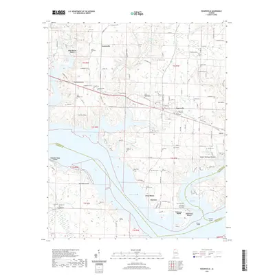
2020 Map of Rogersville
USGS Topo · Published 2020About this map
Rogersville serves as the hub of this Lauderdale County landscape, where the town's grid meets the irregular shoreline of Wheeler Lake and Wheeler Reservoir. The map reveals a dense concentration of family history preserved in local landmarks, including the Old Romine Cem, McCartney Cem, and the Oliver-Bedingfield Memorial Cem. These sites, along with smaller settlements like Thorntontown and Toonersville, reflect the ancestral settlement patterns of northern Alabama before modern expansion. To the south, the terrain descends toward the water, where Weaver Island and the Elk River Shoals mark the confluence of major waterways. The presence of Saltpeter Cave Bluff and various springs like Bolin Spring and Warmack Spring highlights the area's complex hydrology, while names like Slop Hollow and Lock One Hollow provide clues to the historic navigation and land use along the river's edge.
Find a feature on this map
157 named features on this map. Tap any name to fly to it.
Don’t see what you’re looking for? This feature index may not catch every label — zoom into the map to look around manually.
Map Details
Editions of this 2020 Rogersville Map
This is the sole edition of this map. No revisions or reprints were ever made.
Other maps of this area

1914 · Rogersville
USGS Topo · 1:48,000

1916 · Rogersville
USGS Topo · 1:62,500

1936 · Union Hill
USGS Topo · 1:24,000

1936 · Thorntontown
USGS Topo · 1:24,000

1936 · Courtland
USGS Topo · 1:24,000

1936 · Lexington
USGS Topo · 1:24,000

1936 · Hillsboro
USGS Topo · 1:24,000

1936 · Wheeler Dam
USGS Topo · 1:24,000

1936 · Town Creek
USGS Topo · 1:24,000
1936 · Center Hill
USGS Topo · 1:24,000