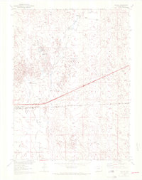
1951 Map of Roggen
USGS Topo · Published 1972About this map
Roggen and its surrounding high plains are defined by a sparse but deliberate arrangement of water resources and transportation infrastructure. The landscape is characterized by intermittent drainage systems including Lost Creek, Sand Creek, and the distinctive Long Draw, which cut through the terrain toward localized water bodies like Monahan Lakes and Waite Lake. The presence of numerous windmill sites across the survey area underscores the necessity of groundwater for the ranching operations established at Lakeside Ranch and Painter Ranch. The southern portion of the map is dominated by the industrial corridor of the Burlington Northern railroad, which parallels a major roadway near the settlement of Roggen. This alignment highlights the era's reliance on rail for moving goods across the Colorado plains, while features like Lost Canyon offer a glimpse into the more varied topography of the Weld County region.
Find a feature on this map
13 named features on this map. Tap any name to fly to it.
Don’t see what you’re looking for? This feature index may not catch every label — zoom into the map to look around manually.
Map Details
Editions of this 1951 Roggen Map
3 editions found
Other maps of this area

1950 · South Roggen
USGS Topo · 1:24,000

1950 · Wiggins SW
USGS Topo · 1:24,000

1950 · Tampa
USGS Topo · 1:24,000

1950 · Prospect Valley
USGS Topo · 1:24,000

1950 · Masters
USGS Topo · 1:24,000

1950 · Hardin
USGS Topo · 1:24,000

1951 · Prospect Valley
USGS Topo · 1:24,000

1951 · Masters
USGS Topo · 1:24,000

1951 · Hardin
USGS Topo · 1:24,000

1951 · Roggen
USGS Topo · 1:24,000