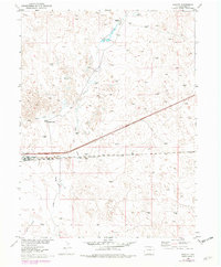
1951 Map of Roggen
USGS Topo · Published 1979About this map
The high plains of Weld County come into focus here, dominated by the railroad operations and ranching life of the mid-20th century. The settlement of Roggen serves as the central hub, situated along the tracks of the Burlington Northern. This transportation corridor is mirrored by the development of Route 76, illustrating the shift in regional transit as highway infrastructure began to parallel the older rail lines.
Find a feature on this map
13 named features on this map. Tap any name to fly to it.
Don’t see what you’re looking for? This feature index may not catch every label — zoom into the map to look around manually.
Map Details
Editions of this 1951 Roggen Map
3 editions found
Other maps of this area

1950 · South Roggen
USGS Topo · 1:24,000

1950 · Wiggins SW
USGS Topo · 1:24,000

1950 · Tampa
USGS Topo · 1:24,000

1950 · Prospect Valley
USGS Topo · 1:24,000

1950 · Masters
USGS Topo · 1:24,000

1950 · Hardin
USGS Topo · 1:24,000

1951 · Prospect Valley
USGS Topo · 1:24,000

1951 · Masters
USGS Topo · 1:24,000

1951 · Hardin
USGS Topo · 1:24,000

1951 · Roggen
USGS Topo · 1:24,000