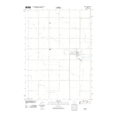
2010 Map of Rolfe
USGS Topo · Published 2010About this map
The prairie landscape of Rolfe in Pocahontas County is defined by a dense grid of section roads and the meandering paths of several key waterways. This 2010 survey illustrates the town's position at the intersection of several local routes, anchored by the Rolfe Post Office and nearby community spaces. To the west, Rubens Siding indicates the region's agricultural rail connections, while the surrounding countryside is marked by established burial grounds including Powhatan Cemetery to the north and the adjacent Saint Margarets Cemetery and Clinton-Garfield Cemetery to the south. The natural drainage of the Iowa plains is evident through the winding courses of Beaver Creek, Pilot Creek, and Crooked Creek, which cut across the rigid township lines. To the far south, North Branch Lizard Creek and the man-made Drainage Ditch Number 169 highlight the managed hydrology essential for local cultivation.
Find a feature on this map
26 named features on this map. Tap any name to fly to it.
Don’t see what you’re looking for? This feature index may not catch every label — zoom into the map to look around manually.
Map Details
Editions of this 2010 Rolfe Map
This is the sole edition of this map. No revisions or reprints were ever made.
Other maps of this area

1954 · Fort Dodge
USGS Topo · 1:250,000

1957 · Fort Dodge
USGS Topo · 1:250,000

1958 · Fort Dodge
USGS Topo · 1:250,000

1979 · Pocahontas
USGS Topo · 1:24,000

1979 · Gilmore City
USGS Topo · 1:24,000

1979 · Palmer
USGS Topo · 1:24,000

1980 · Rolfe
USGS Topo · 1:24,000

1980 · Havelock
USGS Topo · 1:24,000
1980 · Mallard
USGS Topo · 1:24,000

1980 · Plover
USGS Topo · 1:24,000