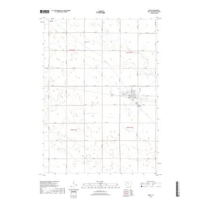
2018 Map of Rolfe
USGS Topo · Published 2018About this map
Rolfe and Plover anchor this corner of Pocahontas County, where the Iowa prairie is defined by a rigorous section-line grid and a series of winding tributaries. The town of Rolfe is concentrated at the intersection of Broad St and Railroad St, while rural life is marked by longstanding landmarks like the Powhatan Cem to the northwest. The drainage of the land is visible through the courses of Beaver Cr, Pilot Cr, and Crooked Cr, which cut diagonally across the survey blocks. To the southeast of the main settlement, Saint Margaret's Cem and Clinton-Garfield Cem stand near the edge of the plat, offering specific points of interest for those researching the early families of this agricultural region.
Find a feature on this map
29 named features on this map. Tap any name to fly to it.
Don’t see what you’re looking for? This feature index may not catch every label — zoom into the map to look around manually.
Map Details
Editions of this 2018 Rolfe Map
This is the sole edition of this map. No revisions or reprints were ever made.
Other maps of this area

1954 · Fort Dodge
USGS Topo · 1:250,000

1957 · Fort Dodge
USGS Topo · 1:250,000

1958 · Fort Dodge
USGS Topo · 1:250,000

1979 · Pocahontas
USGS Topo · 1:24,000

1979 · Gilmore City
USGS Topo · 1:24,000

1979 · Palmer
USGS Topo · 1:24,000

1980 · Rolfe
USGS Topo · 1:24,000

1980 · Havelock
USGS Topo · 1:24,000
1980 · Mallard
USGS Topo · 1:24,000

1980 · Plover
USGS Topo · 1:24,000