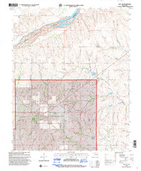
1998 Map of Roll SE
USGS Topo · Published 2001About this map
The Canadian River flows across this Western Oklahoma landscape at the boundary of Ellis and Roger Mills counties. Much of the southern portion of this area is defined by the Black Kettle National Grassland, a conservation area established to restore the shortgrass prairie. The map provides a detailed view of rural life in the late 20th century, where small social centers like the Three Corner Sch and isolated burying grounds such as Lone Bell Cem and Rhome Cem persist amidst the rolling terrain of Benham Hill. A complex network of drainage systems including Sourdough Creek, Quartermaster Creek, and Ninemile Creek dissects the land, illustrating the rugged topography that necessitated the federal grassland protections following the Dust Bowl era.
Find a feature on this map
16 named features on this map. Tap any name to fly to it.
Don’t see what you’re looking for? This feature index may not catch every label — zoom into the map to look around manually.
Map Details
Editions of this 1998 Roll SE Map
This is the sole edition of this map. No revisions or reprints were ever made.
Other maps of this area

1955 · Clinton
USGS Topo · 1:250,000

1957 · Clinton
USGS Topo · 1:250,000

1960 · Cheyenne
USGS Topo · 1:62,500

1960 · Hammon
USGS Topo · 1:62,500

1961 · Leedey
USGS Topo · 1:62,500

1965 · Roll NE
USGS Topo · 1:24,000

1965 · Roll NW
USGS Topo · 1:24,000

1966 · Roll
USGS Topo · 1:24,000

1966 · Roll SE
USGS Topo · 1:24,000

1984 · Foss Reservoir
USGS Topo · 1:100,000