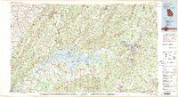
1981 Map of Rome
USGS Topo · Published 1982About this map
Rome sits at the confluence of the Oostanaula River and Etowah River, forming the headwaters of the Coosa River in this detailed look at Northwest Georgia and Northeast Alabama. The landscape is dominated by the long, parallel ridges of Lookout Mountain and Sand Mountain, which guide the path of the Southern Railway and Louisville & Nashville RR through the valleys. The expansive Weiss Lake reservoir serves as a major geographical anchor in the west, while protected lands like Chattahoochee National Forest and De Soto State Park preserve the high-elevation terrain. This map captures the region's complex transportation network connecting industrial centers like Gadsden and Cedartown with smaller communities like Cave Spring and Fort Payne during the early 1980s.
Find a feature on this map
80 named features on this map. Tap any name to fly to it.
Don’t see what you’re looking for? This feature index may not catch every label — zoom into the map to look around manually.
Map Details
Editions of this 1981 Rome Map
2 editions found
Other maps of this area

1885 · Gadsden
USGS Topo · 1:125,000

1886 · Dalton
USGS Topo · 1:125,000

1886 · Ringgold
USGS Topo · 1:125,000

1886 · Rome
USGS Topo · 1:125,000

1886 · Stevenson
USGS Topo · 1:125,000

1888 · Gadsden
USGS Topo · 1:125,000

1888 · Scottsboro
USGS Topo · 1:125,000

1889 · Tallapoosa
USGS Topo · 1:125,000

1889 · Springville
USGS Topo · 1:125,000

1890 · Cartersville
USGS Topo · 1:125,000