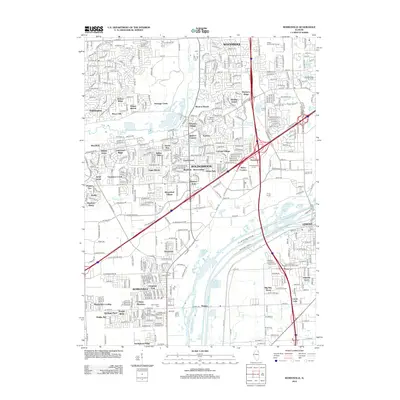
2012 Map of Romeoville
USGS Topo · Published 2012About this map
The Des Plaines River corridor defines the southern half of this landscape, carving a wide path through the industrial and residential transition south of Woodridge and Bolingbrook. Extensive suburban development is evident through numerous named residential pockets such as Winston Village, Cherrywood, and Sugar Brook, which contrast with the large-scale logistics and transit infrastructure of the Internationale Centre. The river valley itself remains a focal point for both industry and nature, containing Rock Lake and the Lilly Cache Slough. Genealogy resources are particularly prominent on this sheet, featuring the Saint Matthew Evangelical Lutheran Cem near the Lemont Industrial Park Airport and several other burial sites including Resurrection Cem and Alexander Cem. Small aviation hubs like Brookridge Air Park and recreation spots like Village Greens Golf Course illustrate the late-twentieth-century character of this growing region.
Find a feature on this map
111 named features on this map. Tap any name to fly to it.
Don’t see what you’re looking for? This feature index may not catch every label — zoom into the map to look around manually.
Map Details
Editions of this 2012 Romeoville Map
This is the sole edition of this map. No revisions or reprints were ever made.
Other maps of this area

1890 · Des Plaines
USGS Topo · 1:62,500

1891 · Riverside
USGS Topo · 1:62,500

1892 · Joliet
USGS Topo · 1:62,500

1893 · Riverside
USGS Topo · 1:62,500

1894 · Des Plaines
USGS Topo · 1:62,500

1900 · Des Plaines
USGS Topo · 1:62,500

1900 · Riverside
USGS Topo · 1:62,500

1901 · Des Plaines
USGS Topo · 1:62,500

1901 · Riverside
USGS Topo · 1:62,500

1908 · Wheaton
USGS Topo · 1:62,500