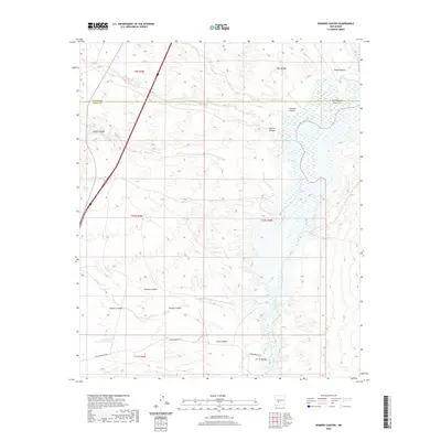
2020 Map of Romero Canyon
USGS Topo · Published 2020About this map
The Rio Grande dominates the eastern half of this arid landscape, where the river's path is carved through significant terrain features like The Narrows. This corridor through the Chihuahuan Desert environment is defined by a dense network of dry washes and drainage systems, including Romero Canyon and Nogal Canyon, which feed toward the river valley. The map documents the boundary between Socorro and Sierra counties, illustrating a region where infrastructure is limited to the western edge along I-25 and scattered water management sites like Joe Pankey Reservoir Number 2. The concentration of named canyons such as Lumber Canyon and China Canyon highlights the complex topographical relief that has shaped land use and accessibility in this part of New Mexico. Local transport is represented by isolated routes like Upper Narrows Rd, serving a largely unpopulated territory defined by its hydrology and relief.
Find a feature on this map
23 named features on this map. Tap any name to fly to it.
Don’t see what you’re looking for? This feature index may not catch every label — zoom into the map to look around manually.
Map Details
Editions of this 2020 Romero Canyon Map
This is the sole edition of this map. No revisions or reprints were ever made.
Other maps of this area

1954 · Tularosa
USGS Topo · 1:250,000

1958 · Tularosa
USGS Topo · 1:250,000

1961 · Huerfano Hill
USGS Topo · 1:24,000

1961 · Sierra Fijardo
USGS Topo · 1:24,000

1961 · Paraje Well
USGS Topo · 1:24,000

1961 · Black Bluffs
USGS Topo · 1:24,000

1961 · Black Hill
USGS Topo · 1:24,000

1961 · Crocker
USGS Topo · 1:24,000

1961 · Lava
USGS Topo · 1:24,000

1961 · Romero Canyon
USGS Topo · 1:24,000