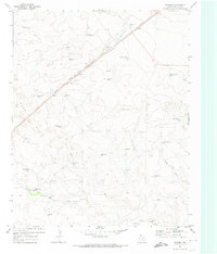
1971 Map of Romero
USGS Topo · Published 1974About this map
Romero sits along the Chicago Rock Island and Pacific railroad line, serving as a primary point of reference in this ranching landscape of Hartley County. The terrain is defined by the sweeping Sand Hills and the seasonal drainages of Spring Creek and Minneosa Spring Creek. Local land use is characterized by an extensive network of named wells and ranching outposts, including Castleberry Ranch and Coots Ranch. These scattered water sources, such as Bull Spring, Petition Well, and Top West Pasture Well, illustrate the critical infrastructure required for cattle operations in the Texas Panhandle during the early 1970s. A Private Landing Strip and several Gravel Pit locations suggest the intersection of modern logistics and resource extraction within a traditional agricultural setting, while a network of Jeep Trails provides access across the shifting sands.
Find a feature on this map
30 named features on this map. Tap any name to fly to it.
Don’t see what you’re looking for? This feature index may not catch every label — zoom into the map to look around manually.
Map Details
Editions of this 1971 Romero Map
This is the sole edition of this map. No revisions or reprints were ever made.
Other maps of this area

1954 · Tucumcari
USGS Topo · 1:250,000

1958 · Tucumcari
USGS Topo · 1:250,000

1971 · Middle Water
USGS Topo · 1:24,000

1971 · Romero SE
USGS Topo · 1:24,000

1971 · Doyle Hill
USGS Topo · 1:24,000

1971 · Amistad SE
USGS Topo · 1:24,000

1971 · Nara Visa
USGS Topo · 1:24,000

1971 · Whiteaker Ranch
USGS Topo · 1:24,000

1971 · Knoblaw
USGS Topo · 1:24,000

1971 · Spring Creek Ranch
USGS Topo · 1:24,000