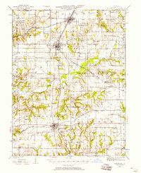
1924 Map of Roodhouse
USGS Topo · Published 1958About this map
The Carrollton and White Hall corridor in the mid-1920s reveals a landscape defined by the intersection of major rail lines and a dense network of rural civic life. The Chicago and Alton and the Chicago Burlington and Quincy railroads serve as the primary conduits for commerce through central Greene County, linking towns like Roodhouse and Wrights to wider markets. Away from the tracks, the terrain is characterized by the winding path of Apple Creek and Horseshoe Lake, providing a natural contrast to the grid-like organization of the surrounding farms. This period is notable for the sheer volume of neighborhood institutions present; the landscape is dotted with family-scale landmarks such as Swamp College School and Bending Oak School, alongside long-standing community hubs like Wesley Church and Hickory Grove Church. These features illustrate the decentralized social structure of Illinois prairie life before the consolidation of rural districts.
Find a feature on this map
74 named features on this map. Tap any name to fly to it.
Don’t see what you’re looking for? This feature index may not catch every label — zoom into the map to look around manually.
Map Details
Editions of this 1924 Roodhouse Map
2 editions found
Other maps of this area

1924 · Winchester
USGS Topo · 1:48,000

1924 · Roodhouse
USGS Topo · 1:62,500

1924 · Griggsville
USGS Topo · 1:62,500

1925 · Brighton
USGS Topo · 1:62,500

1926 · Griggsville
USGS Topo · 1:62,500

1926 · Winchester
USGS Topo · 1:62,500

1926 · Roodhouse
USGS Topo · 1:62,500

1928 · Brighton
USGS Topo · 1:62,500

1930 · Pearl
USGS Topo · 1:62,500

1930 · Hardin
USGS Topo · 1:62,500