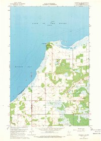
1967 Map of Roosevelt NE
USGS Topo · Published 1969About this map
Arnesen sits prominently on the northern shoreline at Rocky Point, serving as a focal point for this section of Lake of the Woods. The map illustrates a landscape defined by the transition from the open waters of Muskeg Bay to low-lying marshes and scattered agricultural clearings. Further south, the settlement of Laona appears with its local landmarks, including the Mt Carmel Ch and a nearby Cem. Navigation and geological features are clearly marked, from the offshore Gull Rock Light and Twin Rocks to several scattered Gravel Pit locations inland. The boundary line between Roseau and Lake of the Woods counties bisects the area, highlighting the administrative divisions of this northern Minnesota frontier.
Find a feature on this map
12 named features on this map. Tap any name to fly to it.
Don’t see what you’re looking for? This feature index may not catch every label — zoom into the map to look around manually.
Map Details
Editions of this 1967 Roosevelt NE Map
2 editions found
Other maps of this area

1918 · Buffalo Bay
USGS Topo · 1:62,500

1918 · Roosevelt
USGS Topo · 1:62,500

1918 · Williams
USGS Topo · 1:62,500

1943 · Roosevelt
USGS Topo · 1:62,500

1954 · Roseau
USGS Topo · 1:250,000

1957 · Roseau
USGS Topo · 1:250,000

1958 · Roseau
USGS Topo · 1:250,000

1963 · Kenora
USGS Topo · 1:250,000

1967 · Williams
USGS Topo · 1:24,000

1967 · Roosevelt NW
USGS Topo · 1:24,000