
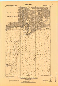
1918 Map of Buffalo Bay
USGS Topo · Published 1918About this map
The international border between the Dominion of Canada and the United States defines the northern reaches of this 1918 military survey. Focusing on the expansive waters of Lake of the Woods, the map documents the shoreline of Beltrami County, Minnesota, and the Provencher District of Manitoba. The landscape is dominated by the vast Buffalo Bay, with soundings indicating the lake floor composition—ranging from clay and mud to sand and gravel—as it was recorded during the Great War era.
Find a feature on this map
12 named features on this map. Tap any name to fly to it.
Don’t see what you’re looking for? This feature index may not catch every label — zoom into the map to look around manually.
Map Details
Editions of this 1918 Buffalo Bay Map
2 editions found
Other maps of this area

1918 · Roosevelt
USGS Topo · 1:62,500
1918 · Oak Island
USGS Topo · 1:62,500

1918 · Williams
USGS Topo · 1:62,500

1918 · Warroad
USGS Topo · 1:62,500

1943 · Roosevelt
USGS Topo · 1:62,500

1943 · Warroad
USGS Topo · 1:62,500

1954 · Roseau
USGS Topo · 1:250,000

1957 · Roseau
USGS Topo · 1:250,000

1958 · Roseau
USGS Topo · 1:250,000

1963 · Kenora
USGS Topo · 1:250,000