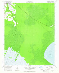
1954 Map of Roper South
USGS Topo · Published 1965About this map
Roper serves as the primary settlement on this mid-century survey, situated at the confluence of human industry and the dense marshlands of the Albemarle-Pamlico peninsula. The landscape is defined by extensive drainage projects, with a network of engineered waterways including the Lewis Canal, Canal A, and Canal B cutting through the saturated soils. To the south and east, the transition from the Dismal Swamp into Lees Mills Swamp illustrates the region's reliance on water management for agriculture and settlement. Educational infrastructure is noted with the inclusion of Clemons High Sch and a secondary High Sch. The vast open waters of Phelps Lake dominate the southeastern corner, while the Newland Main Road and an old Tramway provide the necessary terrestrial links across the low-lying terrain of Skinnersville.
Find a feature on this map
16 named features on this map. Tap any name to fly to it.
Don’t see what you’re looking for? This feature index may not catch every label — zoom into the map to look around manually.
Map Details
Editions of this 1954 Roper South Map
3 editions found
Other maps of this area

1914 · Belhaven
USGS Topo · 1:48,000

1916 · Belhaven
USGS Topo · 1:62,500

1943 · Columbia
USGS Topo · 1:125,000

1943 · Plymouth
USGS Topo · 1:125,000

1953 · Rocky Mount
USGS Topo · 1:250,000

1954 · Rocky Mount
USGS Topo · 1:250,000

1954 · Plymouth East
USGS Topo · 1:24,000

1954 · Roper North
USGS Topo · 1:24,000

1954 · Roper South
USGS Topo · 1:24,000
1954 · Creswell
USGS Topo · 1:24,000