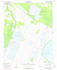
1954 Map of Roper South
USGS Topo · Published 1977About this map
Roper and the small settlement of Clemons anchor the northwestern corner of this landscape, where the coastal plain begins its transition into the vast wetlands of Washington County. This survey, compiled from 1951 photography and updated through the mid-1970s, reveals a highly engineered drainage system critical to the local timber and agricultural economy. A complex network of artificial waterways, including Canal A and Canal B, cuts through the dense reaches of East Dismal and Lees Mills Swamp, illustrating the persistent efforts to manage the water table between the Albemarle Sound and the interior. To the south, the shoreline of Phelps Lake appears alongside Scuppernong, while the northern region near Skinnersville shows the geometric patterns of cleared land and woodlots typical of the era. Significant local markers like the High Sch and Cem in Roper provide specific points of interest for genealogists tracing mid-century community life.
Find a feature on this map
16 named features on this map. Tap any name to fly to it.
Don’t see what you’re looking for? This feature index may not catch every label — zoom into the map to look around manually.
Map Details
Editions of this 1954 Roper South Map
3 editions found
Other maps of this area

1914 · Belhaven
USGS Topo · 1:48,000

1916 · Belhaven
USGS Topo · 1:62,500

1943 · Columbia
USGS Topo · 1:125,000

1943 · Plymouth
USGS Topo · 1:125,000

1953 · Rocky Mount
USGS Topo · 1:250,000

1954 · Rocky Mount
USGS Topo · 1:250,000

1954 · Plymouth East
USGS Topo · 1:24,000

1954 · Roper North
USGS Topo · 1:24,000

1954 · Roper South
USGS Topo · 1:24,000
1954 · Creswell
USGS Topo · 1:24,000