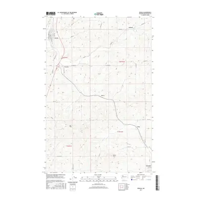
2017 Map of Rosalia
USGS Topo · Published 2017About this map
Rosalia and Oakesdale anchor this portion of the Palouse, a region defined by complex topographic contours and a dense network of country roads. The landscape is primarily shaped by agriculture and the drainages of Pine Cr and McCoy Cr, which wind through the township sections. Small named localities like McCoy, Pandora, and Donahue represent the historical rural hubs of Whitman County, while Flaig sits along the road network to the southeast. Local history is grounded in specific sites such as Riggs Cem near the northern boundary and prominent landforms like Naff Ridge and Granite Butte. The transition from the Old State Hwy to modern routes illustrates the evolution of transport through these rolling hills, which remain divided by the systematic grid of the Public Land Survey System, including t20n r43e and t19n r44e.
Find a feature on this map
42 named features on this map. Tap any name to fly to it.
Don’t see what you’re looking for? This feature index may not catch every label — zoom into the map to look around manually.
Map Details
Editions of this 2017 Rosalia Map
This is the sole edition of this map. No revisions or reprints were ever made.
Other maps of this area

1903 · Oakesdale
USGS Topo · 1:125,000

1905 · Oakesdale
USGS Topo · 1:125,000

1954 · Spangle
USGS Topo · 1:62,500

1954 · Fairfield
USGS Topo · 1:62,500

1955 · Spokane
USGS Topo · 1:250,000

1958 · Spokane
USGS Topo · 1:250,000

1964 · Oakesdale
USGS Topo · 1:24,000

1964 · Malden
USGS Topo · 1:24,000
1964 · Steptoe
USGS Topo · 1:24,000
1964 · Garfield
USGS Topo · 1:24,000