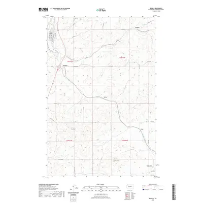
2020 Map of Rosalia
USGS Topo · Published 2020About this map
Rosalia and Oakesdale anchor this portion of the Palouse region, where the agricultural landscape is defined by the winding course of Pine Cr and several smaller tributaries. The area is characterized by high-relief landforms such as Naff Ridge and Granite Butte, which stand above the surrounding wheat country. A significant feature of the modern landscape is the Palouse To Cascades State Park Trail, which follows the corridor once occupied by the Chicago, Milwaukee, St. Paul and Pacific Railroad. Smaller, historic junctions and sidings like Pandora, Donahue, McCoy, and Flaig are scattered along the rail routes and creek bottoms. For family historians, the location of Riggs Cem near the northern border provides a specific point of genealogical interest. The map documents the persistent rural road network, featuring family-named routes such as L D Johnson Rd and Merritt Rd.
Find a feature on this map
40 named features on this map. Tap any name to fly to it.
Don’t see what you’re looking for? This feature index may not catch every label — zoom into the map to look around manually.
Map Details
Editions of this 2020 Rosalia Map
This is the sole edition of this map. No revisions or reprints were ever made.
Other maps of this area

1903 · Oakesdale
USGS Topo · 1:125,000

1905 · Oakesdale
USGS Topo · 1:125,000

1954 · Spangle
USGS Topo · 1:62,500

1954 · Fairfield
USGS Topo · 1:62,500

1955 · Spokane
USGS Topo · 1:250,000

1958 · Spokane
USGS Topo · 1:250,000

1964 · Oakesdale
USGS Topo · 1:24,000

1964 · Malden
USGS Topo · 1:24,000
1964 · Steptoe
USGS Topo · 1:24,000
1964 · Garfield
USGS Topo · 1:24,000