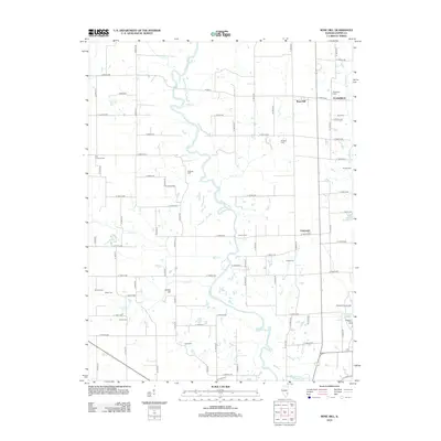
2012 Map of Rose Hill
USGS Topo · Published 2012About this map
The Embarras River meanders through the heart of this Jasper County landscape, defining the rural geography between the settlements of Rose Hill and Falmouth. The river's winding course is fed by numerous tributaries including Wolf Cr, Lick Cr, and Mint Cr, creating a complex network of wetlands and oxbows. For family historians, the area is rich with small burial grounds such as Redford Cem, Coburn Cem, and Chaple Cem, which dot the agricultural sections alongside more prominent sites like Plainfield Cem near Plainfield. Toward the southern edge, the terrain transitions to recreational space near Sam Parr Lake, featuring the Shadbush Picnic Area and Dogwood Picnic Area. This 2012 snapshot records the enduring grid of county roads, such as Co Hwy-6, that connects these quiet communities and family-named landmarks like Jordan Hill.
Find a feature on this map
74 named features on this map. Tap any name to fly to it.
Don’t see what you’re looking for? This feature index may not catch every label — zoom into the map to look around manually.
Map Details
Editions of this 2012 Rose Hill Map
This is the sole edition of this map. No revisions or reprints were ever made.
Other maps of this area

1940 · Greenup
USGS Topo · 1:62,500

1941 · Newton
USGS Topo · 1:62,500

1943 · Greenup
USGS Topo · 1:62,500

1943 · Newton
USGS Topo · 1:62,500

1953 · Teutopolis
USGS Topo · 1:62,500

1953 · Sailor Springs
USGS Topo · 1:62,500

1958 · Decatur
USGS Topo · 1:250,000

1958 · Belleville
USGS Topo · 1:250,000

1961 · Decatur
USGS Topo · 1:250,000

1962 · Belleville
USGS Topo · 1:250,000