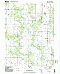
1998 Map of Rose Hill
USGS Topo · Published 2002About this map
Embarras River meanders through the heart of this landscape, its winding course defining the central drainage between the townships of Grove and Wade. The agricultural character of the region is punctuated by numerous Oil Fields and a network of creeks, including Wolf Creek and Lick Creek, that feed into the larger river system. Near the southern boundary, the transition from rural acreage to protected land is marked by the presence of Sam Parr State Park and Glenn Lake.
Find a feature on this map
20 named features on this map. Tap any name to fly to it.
Don’t see what you’re looking for? This feature index may not catch every label — zoom into the map to look around manually.
Map Details
Editions of this 1998 Rose Hill Map
This is the sole edition of this map. No revisions or reprints were ever made.
Other maps of this area

1940 · Greenup
USGS Topo · 1:62,500

1941 · Newton
USGS Topo · 1:62,500

1943 · Greenup
USGS Topo · 1:62,500

1943 · Newton
USGS Topo · 1:62,500

1953 · Teutopolis
USGS Topo · 1:62,500

1953 · Sailor Springs
USGS Topo · 1:62,500

1958 · Decatur
USGS Topo · 1:250,000

1958 · Belleville
USGS Topo · 1:250,000

1961 · Decatur
USGS Topo · 1:250,000

1962 · Belleville
USGS Topo · 1:250,000