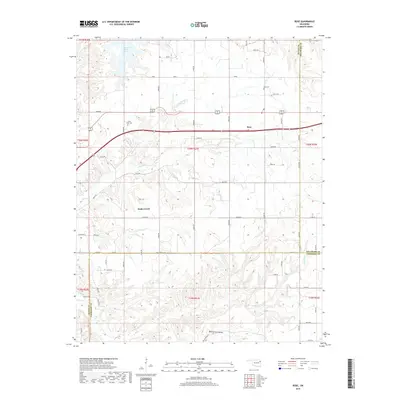
2019 Map of Rose
USGS Topo · Published 2019About this map
Rose and the surrounding township lines of Northeastern Oklahoma are defined here by a network of rural roads and rugged drainages. The landscape is heavily influenced by the waters of Chimney Rock Lake in the northwest and several significant tributaries including Little Spring Cr and Snake Cr. Local history is preserved at sites like Rose Cem and Little Rock Cem, which serve as anchors for genealogists researching families from this corner of Mayes and Delaware Counties. The terrain varies from the flat stretches along Co Line Rd to the more varied topography of Blacksmith Hollow in the south. This modern survey reflects the enduring rural character of the region, where family-named routes like Jess Mounce Rd connect scattered homesteads and agricultural tracts across the Ozark foothills.
Find a feature on this map
57 named features on this map. Tap any name to fly to it.
Don’t see what you’re looking for? This feature index may not catch every label — zoom into the map to look around manually.
Map Details
Editions of this 2019 Rose Map
This is the sole edition of this map. No revisions or reprints were ever made.
Other maps of this area

1896 · Pryor
USGS Topo · 1:125,000

1899 · Siloam Springs
USGS Topo · 1:125,000

1901 · Pryor
USGS Topo · 1:125,000

1903 · Siloam Springs
USGS Topo · 1:125,000

1904 · Siloam Springs
USGS Topo · 1:125,000

1954 · Tulsa
USGS Topo · 1:250,000

1958 · Tulsa
USGS Topo · 1:250,000

1963 · Tulsa
USGS Topo · 1:250,000

1971 · Kenwood
USGS Topo · 1:24,000
1971 · Salina
USGS Topo · 1:24,000