1972 Map of Rose
USGS Topo · Published 1974About this map
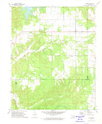
The community of Rose sits at the intersection of several local routes in the early 1970s, serving as a hub for the surrounding rural area of Mayes County. The landscape is defined by the winding paths of Snake Creek and Little Rock Creek, with several schools and churches marking the social center of the township. Local history and genealogy interest is found in the distribution of community buildings like Little Rock Sch and Little Rock Ch, alongside the Little Rock Cem and Rose Cem. In the southern portion of the map, the terrain transitions toward the Peggs and Murphy regions, where the drainage of Blacksmith Hollow and the Shale Pits indicate the local geography's utility. The presence of the Rose Lookout Tower suggests the elevation and forested character of the eastern Oklahoma hills at this time.
Find a feature on this map
28 named features on this map. Tap any name to fly to it.
Don’t see what you’re looking for? This feature index may not catch every label — zoom into the map to look around manually.
Map Details
Editions of this 1972 Rose Map
This is the sole edition of this map. No revisions or reprints were ever made.
Other maps of this area

1896 · Pryor
USGS Topo · 1:125,000

1899 · Siloam Springs
USGS Topo · 1:125,000

1901 · Pryor
USGS Topo · 1:125,000

1903 · Siloam Springs
USGS Topo · 1:125,000

1904 · Siloam Springs
USGS Topo · 1:125,000

1954 · Tulsa
USGS Topo · 1:250,000

1958 · Tulsa
USGS Topo · 1:250,000

1963 · Tulsa
USGS Topo · 1:250,000
1971 · Kenwood
USGS Topo · 1:24,000
1971 · Salina
USGS Topo · 1:24,000