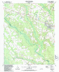
1987 Map of Roseboro
USGS Topo · Published 1987About this map
The South River and its vast network of wetlands, including the Big Swamp and Little Coharie Swamp, dominate this mid-1980s landscape at the boundary of Sampson and Cumberland Counties. The town of Roseboro serves as the primary hub, where the CSX railroad and local roads intersect, supporting a mix of agricultural and industrial uses evidenced by a nearby Claypit and Sandpit. To the northwest, the settlement of Hayne sits along the rail line, while the rural interior is dotted with numerous family and community landmarks. Genealogists will find a high density of small burial sites and country churches, such as Pleasant Union Ch and Brick Mill Ch. Unique terrain features like Piney Pocosin and Big Pond Bay suggest the specific ecological character of the coastal plain, while the Old Railroad Grade north of Roseboro points to a former transportation corridor no longer in active use.
Find a feature on this map
34 named features on this map. Tap any name to fly to it.
Don’t see what you’re looking for? This feature index may not catch every label — zoom into the map to look around manually.
Map Details
Editions of this 1987 Roseboro Map
This is the sole edition of this map. No revisions or reprints were ever made.
Other maps of this area

1909 · Coharie
USGS Topo · 1:62,500

1953 · Florence
USGS Topo · 1:250,000

1953 · Raleigh
USGS Topo · 1:250,000

1954 · Florence
USGS Topo · 1:250,000

1954 · Raleigh
USGS Topo · 1:250,000

1959 · Roseboro
USGS Topo · 1:62,500

1959 · Garland
USGS Topo · 1:62,500

1974 · Salemburg
USGS Topo · 1:24,000
1974 · Stedman
USGS Topo · 1:24,000

1982 · Elizabethtown
USGS Topo · 1:100,000