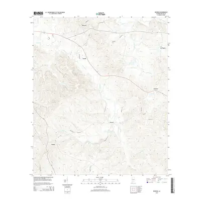
2014 Map of Rosebud
USGS Topo · Published 2014About this map
Pursley Cr and its various tributaries, including the W Prong Pursley Cr and E Prong Pursley Cr, define the drainage patterns of this portion of Wilcox County. The landscape is dotted with several small crossroads communities that have long served as local landmarks. Rosebud sits in the eastern half of the area, while Fatama occupies the southwestern corner near Fire Tower Rd. To the north, Shawnee and Estelle are connected by a network of rural routes including CR 65 and Meadowbrook St. This area reflects a traditional rural Alabama settlement pattern, where small clusters of homes and farms are situated at the intersections of county roads such as Rosebud Rd and Paul Jones Rd. The terrain is also marked by Shoal Cr and the winding course of Pine Barren Cr in the northeast near Darlington.
Find a feature on this map
32 named features on this map. Tap any name to fly to it.
Don’t see what you’re looking for? This feature index may not catch every label — zoom into the map to look around manually.
Map Details
Editions of this 2014 Rosebud Map
This is the sole edition of this map. No revisions or reprints were ever made.
Other maps of this area

1953 · Montgomery
USGS Topo · 1:250,000

1953 · Andalusia
USGS Topo · 1:250,000

1956 · Montgomery
USGS Topo · 1:250,000

1957 · Montgomery
USGS Topo · 1:250,000

1957 · Andalusia
USGS Topo · 1:250,000

1957 · Carlowville
USGS Topo · 1:62,500

1973 · Camden South
USGS Topo · 1:24,000

1973 · Vredenburgh
USGS Topo · 1:24,000
1974 · Camden North
USGS Topo · 1:24,000
1981 · Rosebud
USGS Topo · 1:24,000