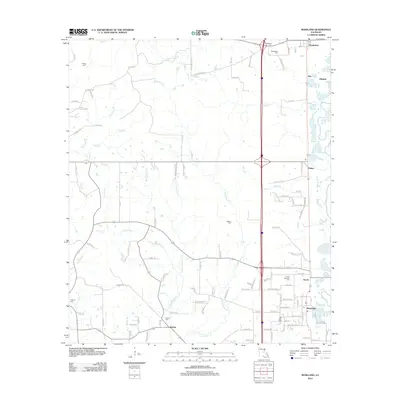
2012 Map of Roseland
USGS Topo · Published 2012About this map
The Tangipahoa River defines the eastern boundary of this corridor, where the legacy of early 20th-century logging and rail transport has evolved into a landscape of quiet communities. The map highlights a series of settlements including Tangipahoa, Fluker, Arcola, and Roseland, each connected by a primary north-south transportation artery. This area of Tangipahoa Parish is notably dense with family and community burial grounds, such as Tangipahoa Cem, Kedron Cem, and Phillips Cem, which provide significant anchor points for local genealogical research. The drainage patterns of the Natalbany Cr and its various branches, like S Fork Jenny Br and W Natalbany Cr, illustrate the complex hydrology that influenced original land parcels and the placement of roads like Bethel Rd and Parish Road 24. Scattered small water bodies such as Robinson Pond and Mud Cr further detail the rural character of this Louisiana landscape.
Find a feature on this map
115 named features on this map. Tap any name to fly to it.
Don’t see what you’re looking for? This feature index may not catch every label — zoom into the map to look around manually.
Map Details
Editions of this 2012 Roseland Map
This is the sole edition of this map. No revisions or reprints were ever made.
Other maps of this area

1940 · Spring Creek
USGS Topo · 1:31,680

1940 · Roseland
USGS Topo · 1:31,680

1942 · Roseland
USGS Topo · 1:31,680

1942 · Montpelier
USGS Topo · 1:31,680

1942 · Liverpool
USGS Topo · 1:31,680

1942 · Loranger
USGS Topo · 1:31,680

1949 · Bolivar
USGS Topo · 1:31,680

1949 · Amite
USGS Topo · 1:31,680

1950 · Kentwood
USGS Topo · 1:31,680

1950 · Greensburg
USGS Topo · 1:31,680